These four pages contain views in the White Mountains of northern New Hampshire. This page is views in the White Mountain National Forest. The next page includes Kancamagus Highway views and the last two pages were taken at Franconia Notch State Park.
Page 1 of 4
May 31-June 4, 2011
View from the top of Cathedral Ledge
![[Panoramic view of the heavily treed mountains and valley with many clouds in the sky. In the foreground is the fenced edge of the cliff.]](Photo/New-Hampshire/Cathedral ledge view.jpg)
Peering over the edge of Cathedral Ledge in Echo Lake State Park to see the homes 700 feet below.
(They look like something from a model train setup!)
![[Heavily treed landscape with a few homes and a road visible in the green blanket. In the foreground is the edge of the cliff.]](Photo/New-Hampshire/Cathedral ledge homes.jpg)
Echo Lake
![[Heavily treed landscape with a relatively small cirle of water in the middle of the trees.]](Photo/New-Hampshire/Echo Lake.jpg)
Mount Washington, the highest peak in the northeastern United States at 6,288 feet, still has snow on the hillsides.
![[Panoramic view of the heavily treed mountains and valley with many clouds in the sky. In the foreground is the fenced edge of the cliff.]](Photo/New-Hampshire/Mt Washington 1.jpg)
The other side of Mount Washington
Note the rail line winding up the left side of the photo on its way to the peak of the mountain.
![[Close up view of the mountain with an opening in the trees wider than the rail line winding up the left side of the image. Clouds overhead cast shadows on part of the mountain obscuring the view of the rocky top.]](Photo/New-Hampshire/Mt Washington 2.jpg)
Mount Washington Resort at Bretton Woods, New Hampshire
![[The exterior of a four star resort. All white walls and a maroon roof set among evergreens with Mount Washington as a backdrop under blue skies with a few clouds. A small gatehouse and a large, well-manicured lawn sit in front of the resort.]](Photo/New-Hampshire/Mt Washington Resort.jpg)
Wild Hydrangea
![[A multi-blossomed flower with very small, five-petaled flowers in the center and larger four-petaled flowers surrounding the smaller ones and set on large, green, oval leaves.]](Photo/New-Hampshire/white flower.jpg)
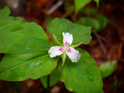
Painted Trillium

The smooth trail to Diana's Baths
![[A perfectly smooth, but not paved path among the tall trees. Quite wheel-chair accessible.]](Photo/New-Hampshire/Dianas Baths path.jpg)
Part of the multi-stepped waterfall known as Diana's Baths
![[Lots of horizontal light-colored granite slabs stacked on three different levels. Waterfalls seen in two spots leading to a pool of water in the foreground.]](Photo/New-Hampshire/Dianas Baths.jpg)
The rocky trail to Crystal Cascades waterfall
![[A dirt trail with rocks anywhere from small pebbles to up to a foot in size.]](Photo/New-Hampshire/Crystal Cascades trail.jpg)
Interesting rock on the trail to Crystal Cascades
![[Rock close to 2 feet in diameter containing what appears to be petrified vegetation remains.]](Photo/New-Hampshire/interesting rock.jpg)
Crystal Cascades
![[Two images stitched vertically to cover both the upper and lower parts of the cascades. The upper portion is much taller and wider than the lower portion. In between the two is a pool. The lower portion goes to the left after the upper portion falls into the pool.]](Photo/New-Hampshire/Crystal Cascades.jpg)
Stone steps to reach the bottom of Glen Ellis Falls
![[A wide, curving, stone staircase with a wood post railing set on the hillside.]](Photo/New-Hampshire/Glen Ellis Falls stairs.jpg)
Rock in the water above the main falls at Glen Ellis Falls (The color pattern reminded me of snake skin.)
![[Shallow water with a tan and black patterned rock bottom visible through it. Surrounding it are dry grey and salmon colored rock.]](Photo/New-Hampshire/Glen Ellis Falls rock.jpg)
Glen Ellis Falls upper level (Upper falls is at far left while the main falls drops more than 60 feet off the far right of the image.)
![[Several photos stitched together showing a falls on the far left, then rushing water winding around rocks to a small pool and then the water flow disappearing into some large rocks on the right. Several large rust-colored boulders are on the far side against the hill while flatter rock is in the foreground.]](Photo/New-Hampshire/Glen Ellis Falls.jpg)
Continue to Kancamagus Highway images. (page 2 of 4)
All photos © S. M. Garver